
Before the advent of modern technology, ancient cultures relied on the stars for navigation, guiding their journeys across vast oceans and uncharted lands. Ancient astral navigation was a crucial skill that allowed early civilizations to explore and connect distant regions. This article delves into the fascinating methods and practices of how early cultures used celestial bodies to chart their courses and navigate their world.
The Origins of Astral Navigation
Astral navigation, the practice of using celestial bodies for orientation and travel, has its origins in the earliest human societies. As far back as 2000 BCE, ancient cultures began observing the night sky and recognizing patterns among the stars. These observations were not only vital for tracking the passage of time but also for navigating across large distances.
The first known use of astral navigation comes from ancient Mesopotamia, where the Babylonians meticulously recorded the positions of celestial bodies. Their astronomical records were instrumental in developing early star maps and navigation techniques. Similarly, ancient Egyptians employed stellar observations to align their monuments and guide their travels.
The Role of Star Maps in Ancient Navigation
Star maps: played a fundamental role in ancient astral navigation. These diagrams depicted the positions of key stars and constellations, serving as guides for travelers and explorers. Ancient cultures created and used these maps to navigate across both land and sea.
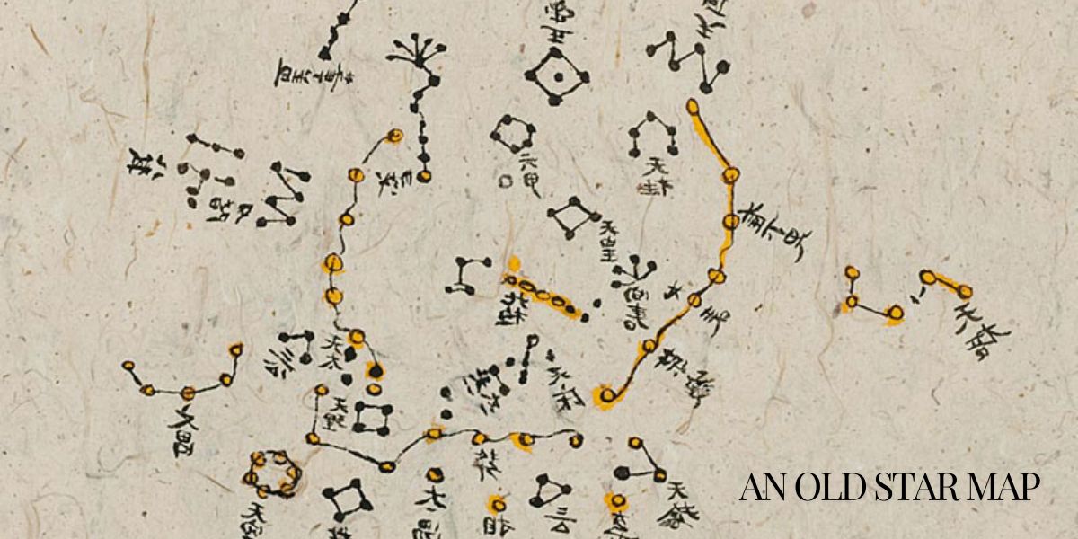
In the Mediterranean region, the Greeks and Phoenicians were prominent practitioners of celestial navigation. The Greeks developed star charts that included constellations such as the Ursa Major and Ursa Minor, which were crucial for determining direction. The Phoenicians, renowned for their seafaring skills, used the North Star, Polaris, as a reference point for their voyages. Polaris’s fixed position in the sky made it a reliable indicator of north, allowing sailors to maintain a consistent heading.
In the southern hemisphere, ancient Polynesians utilized a different set of constellations and stellar phenomena. Their navigation techniques were sophisticated, involving mental maps of star positions and the use of the Southern Cross constellation. The Polynesians also combined their knowledge of the stars with ocean swells and bird migration patterns to guide their long voyages across the Pacific Ocean.
How Ancient Cultures Used Celestial Bodies for Navigation
Ancient cultures employed various celestial bodies in their navigation practices, each contributing to their understanding of direction and location.
The Sun: The sun’s consistent rising and setting patterns provided a basic framework for navigation. By tracking the position of the sun throughout the day, ancient sailors could determine their latitude. This method was particularly useful for daytime travel. Ancient Egyptians, for instance, used the sun to align their pyramids and temples, reflecting their understanding of celestial movements.
The Moon: The moon also played a significant role in ancient navigation. Its phases and movements were used to track time and determine positional data. During a lunar eclipse, ancient navigators could compare the moon’s shadow with known star positions to confirm their location.
Stars and Constellations: Stars and constellations were central to ancient navigation. The Greeks relied on constellations such as the Big Dipper, while the Polynesians used the Southern Cross. Ancient mariners observed the positions of these celestial bodies relative to the horizon to establish their position and direction.
Star Paths: Some ancient navigators used star paths, imaginary lines in the sky connecting prominent stars. These paths helped sailors maintain their course by aligning their position with the stars’ projected pathways. For instance, the Greeks’ use of star paths involved aligning with specific constellations to gauge direction.
Astronomical Tools and Techniques
While early navigators primarily relied on their knowledge of the stars, several astronomical tools and techniques enhanced their accuracy.
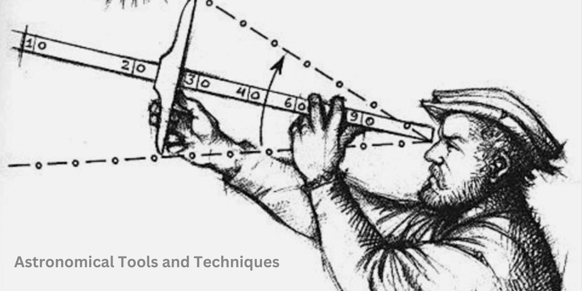
The Astrolabe: The astrolabe, an ancient instrument used to measure the altitude of celestial bodies, was crucial for determining latitude. Developed by the Greeks and later refined by Islamic scholars, the astrolabe allowed navigators to calculate their position with greater precision. By aligning the astrolabe with a star or the sun, sailors could ascertain their distance north or south of the equator.
The Sextant: The sextant, introduced in the 18th century, was a significant advancement in celestial navigation. This tool measured the angle between a celestial body and the horizon, providing more accurate positional data. The sextant, combined with detailed star maps, revolutionized navigation and expanded the possibilities for exploration.
The Impact of Astral Navigation on Exploration
Astral navigation had a profound impact on exploration and the expansion of civilizations. Ancient navigators used their celestial knowledge to undertake remarkable voyages that reshaped the world’s understanding of geography.
The Phoenicians: The Phoenicians, skilled sailors from the Mediterranean, used astral navigation to explore and establish trade routes across the Mediterranean Sea and beyond. Their ability to navigate using the stars allowed them to connect diverse cultures and regions.
The Vikings: Viking explorers used celestial navigation to reach distant lands such as Iceland, Greenland, and North America. Their knowledge of the stars, combined with rudimentary compasses and maps, enabled them to venture into uncharted territories.
Polynesians: The Polynesians demonstrated unparalleled skill in astral navigation as they explored the vast Pacific Ocean. Their understanding of the stars and natural phenomena allowed them to settle distant islands and establish trade networks across the ocean.
The Legacy of Ancient Astral Navigation
The legacy of ancient astral navigation endures in modern navigation practices. While contemporary technology has transformed the way we navigate, the principles of celestial navigation remain foundational to our understanding of the world.
Astronomical instruments such as the astrolabe and sextant paved the way for modern navigational tools and techniques. The study of ancient star maps and navigation practices provides valuable insights into the ingenuity and resourcefulness of early explorers.
Today, sailors, pilots, and even astronauts still learn the basics of celestial navigation as part of their training. The timeless practice of using the stars for guidance serves as a reminder of humanity’s enduring curiosity and exploration.
Conclusion
Ancient Astral Navigation: How Early Cultures Traveled by Stars is a testament to human ingenuity and the remarkable ability of early civilizations to harness the power of the night sky. From the Phoenicians and Greeks to the Polynesians and Vikings, ancient navigators used their understanding of celestial bodies to explore and connect distant lands. Their methods, tools, and star maps laid the groundwork for future exploration and continue to inspire our quest for knowledge and discovery.